- Faster Camera: You can now take photos from a quick access button on the map screen. Added setting to skip entering photo remarks before saving.
- Added option to save a copy of the photos to the Gallery.
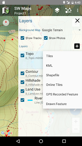
- You can now zoom to the extents of each layer from the layers sidebar
- PRJ files are now optional for shapefile layers. Defaults to WGS84 Lat/Lon
-Notifications when GNSS receiver or NTRIP client is disconnected.
-Bug fixes
- Fixed project upgrade from old database versions
- Fixed map scale view in drawing mode
- Bug fixes
- Added support for more EPSG projections
- Attribute locking when recording point features, to apply same attributes to the next point.
- Fixed Shapefile attribute displayed as integer only
- Fixed external feature attribute ordering
-Bug fixes
- NTRIP Client Send GGA fixes
- Mock location output can be toggled in app settings.
- Tracking settings (minimum distance, time and accuracy) can be set from app settings.
- Ability to enter point elevation in Feet instead of meters
- Use orthometric height as point label
- Bug fixes
For a complete list of changes, please check the full release notes at https://aviyaantech.com/swmaps/changelog-android.html
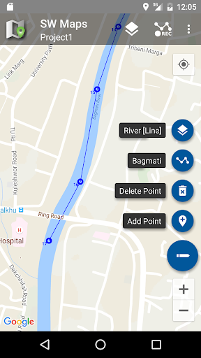
Added track recording for line and polygon features
Bug fixes
For a complete list of changes, please check the full release notes at https://aviyaantech.com/swmaps/changelog-android.html
SW Maps Version 3.0 has many improvements, including a much faster map renderer, custom projection system, improved feature stakeout and more.
For a complete list of changes, please check the full release notes at https://aviyaantech.com/swmaps/changelog-android.html
SW Maps Version 3.0 has many improvements, including a much faster map renderer, custom projection system, improved feature stakeout and more.
For a complete list of changes, please check the full release notes at https://aviyaantech.com/swmaps/changelog-android.html
SW Maps Version 3.0 has many improvements, including a much faster map renderer, custom projection system, improved feature stakeout and more.
For a complete list of changes, please check the full release notes at https://aviyaantech.com/swmaps/changelog-android.html
SW Maps Version 3.0 has many improvements, including a much faster map renderer, custom projection system, improved feature stakeout and more.
For a complete list of changes, please check the full release notes at https://aviyaantech.com/swmaps/changelog-android.html
SW Maps Version 3.0 has many improvements, including a much faster map renderer, custom projection system, improved feature stakeout and more.
For a complete list of changes, please check the full release notes at https://aviyaantech.com/swmaps/changelog-android.html
Improvements in handling of NMEA 4.11 sentences.
Fixed shapefile attribute not showing decimal points in some cases.
Improved support for SparkFun RTK Torch receivers
New "Checklist" attribute type for selecting multiple values from a list.
Export DOP and number of GNSS satellites in spreadsheet and CSV exports.
Fixed display of point elevations for drawn layers.
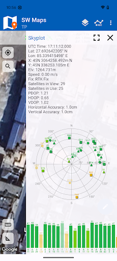
Added NAVIC (IRNSS) NMEA decoding for skyplot
Bug fix for polygon shapefile rendering
Added Mettatec X5 instrument profile
BLE and Geoid File Improvements
Fix for Android 14 Bluetooth LE GNSS connection
Added ROLAVI GNSS profile
Automatically locate external layer files when moved from device storage to SD card
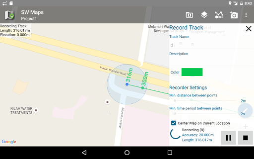
Record track minimum distance can now be set to 0.1m, 0.2m and 0.5m.
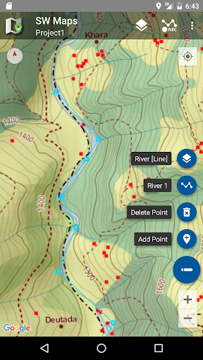
Added point and line stakeout tool. You can now use SW Maps to easily locate your points and lines on the ground.
Added ArduSimple BLE Bridge instrument
Track recording required accuracy can now be set to 1m
NTRIP support for Septentrio receivers
Measurement tools fix for drawing mode
Export fix quality, speed and bearing and accuracy for drawn layers if point is collected using GNSS
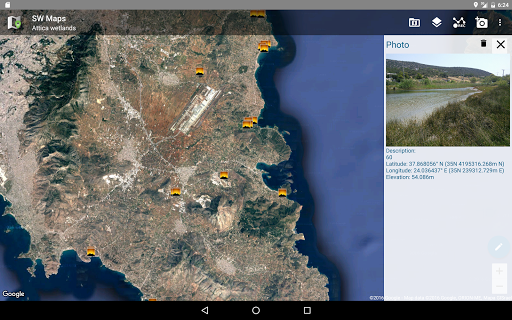
Record and display bearing for photo points
Fixed some external tile layers not loading
Fixed incorrect base station coordinate display for some reference stations
Project names and NTRIP mountpoints are now sorted alphabetically
Measurement tool now snaps to markers on the map
Minor fixes to GPKG and CSV export
Improved Android 12 Compatibility for Bluetooth GNSS receivers and NTRIP.
GNSS status now shows the baseline length when the NTRIP caster is connected to an RTCM3 stream.
Improved handling of shapefiles, GPKG and WMS in coordinates other than WGS84 Geographic.
Mock Location Provider: You can now set SW Maps as a mock location provider in the developer options. This lets you use SW Maps Bluetooth/USB GNSS receivers as a location source for other apps.
Fix for location not working on Android 11 and 12.
Improvements to Android 11 support. Data files are now stored in the app-specific media directory in Android/media. The current SW Maps directory is now shown in the app settings. The add layer dialogs also show the layer folder path.
You can now load Geoid files in gtx format. Copy the gtx files to the SW_Maps/Geoid folder, and select the active geoid in app settings. Orthometric height is recorded and exported for all points.
Many bug fixes
You can now load Geoid files in gtx format. Copy the gtx files to the SW_Maps/Geoid folder, and select the active geoid in app settings. Orthometric height is recorded and exported for all points.
Added option to apply base station antenna PCO to u-blox based receivers based on the antenna model transmitted in the RTCM correction messages.
GNSS Receiver connection using Bluetooth LE now supported.
Many bug fixes
Fixed a problem with NTRIP VRS connections
Fixed track record stopping in Android 10
GNSS Receiver connection using Bluetooth LE now supported.
Major improvements to drawing mode. Can show OpenStreetMap and Mbtiles/WMS/XYZ layers in drawing mode.
Vibration feedback on point record. Can be enabled or disabled in settings.
The feature information screen now shows distance and bearing to the
selected point from the current location.
Many bug fixes
Fixed track record stopping in Android 10
GNSS Receiver connection using Bluetooth LE now supported.
Major improvements to drawing mode. Can show OpenStreetMap and Mbtiles/WMS/XYZ layers in drawing mode.
Vibration feedback on point record. Can be enabled or disabled in settings.
The feature information screen now shows distance and bearing to the
selected point from the current location.
Quickly switch between GPS recording and drawing features for a drawn layer.
Many bug fixes
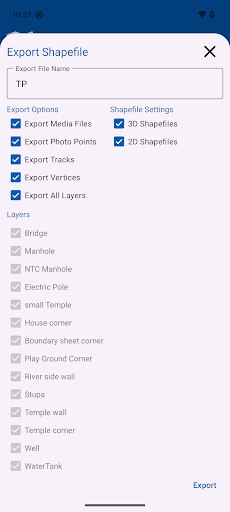
Added KML export option when exporting KMZ.
Instrument height is now exported to spreadsheet for point features.
Quickly switch between GPS recording and drawing features for a drawn layer.
Added Snap On/Off toggle for drawing
Added instrument profile for SparkFun RTK Surveyor
Many bug fixes
Fixed VRS connection issue in southern hemisphere.
Improved support for USB receivers.
Improved support for USB receivers.
Added setting for changing point marker size
Upgraded location provider to use NMEA instead of the Android location provider to prevent Fake GPS usage.
Fix for NTRIP VRS connection not working when using certain languages.
Ability to minimize the record feature sidebar for better map visibility when recording.
Accuracy display when recording feature.
You may now record features in a drawn feature layer using GPS.
Upgraded location provider to use NMEA instead of the Android location provider.
Fix for NTRIP VRS connection not working when using certain languages.
Ability to minimize the record feature sidebar for better map visibility when recording.
Accuracy display when recording feature.
You may now record features in a drawn feature layer using GPS.
Fixes and Improvements
Ability to minimize the record feature sidebar for better map visibility when recording.
Accuracy display when recording feature.
You may now record features in a drawn feature layer using GPS.
Fix for WMS layers which require a Style parameter.
NTRIP client can now request sourcetable.
Bluetooth RTK Support for Pentax G3100 Receivers
Added experimental drawing mode, which can be enabled in settings. Drawing mode allows zooming with no limit.
Fixes and Improvements
NTRIP client can now request sourcetable.
Bluetooth RTK Support for Pentax G3100 Receivers
Added support for NMEA GST sentences. Position accuracy is now displayed in the "GPS Status" page.
Improved Shapefile, KML and Geopackage support
Categorized styling for Geopackage layers
Added experimental drawing mode, which can be enabled in settings. Drawing mode allows zooming with no limit.
Fixes and Improvements
Bluetooth RTK Support for Pentax G3100 Receivers
Added support for NMEA GST sentences. Position accuracy is now displayed in the "GPS Status" page.
Improved Shapefile, KML and Geopackage support
Categorized styling for Geopackage layers
Added experimental drawing mode, which can be enabled in settings. Drawing mode allows zooming with no limit.
Added setting for showing internal GPS location when external receiver is connected.
Added support for NMEA GST sentences. Position accuracy is now displayed in the "GPS Status" page.
Improved Shapefile, KML and Geopackage support
Categorized styling for Geopackage layers
Added experimental drawing mode, which can be enabled in settings. Drawing mode allows zooming with no limit.
Added support for u-blox RTK receivers. You can now connect to NTRIP casters to provide corrections to u-blox RTK receivers (M8P, F9P).
Minor bug fixes
Added support for u-blox RTK receivers. You can now connect to NTRIP casters to provide corrections to u-blox RTK receivers (M8P, F9P). Also added experimental support for VRS corrections for u-blox RTK receivers.
Improved Shapefile, KML and Geopackage support
Categorized styling for Geopackage layers
Setting for specifying minimum GNSS fix quality (RTK, DGPS or Single) for recording features and tracks
Minor bug fixes
Added support for u-blox RTK receivers. You can now connect to NTRIP casters to provide corrections to u-blox RTK receivers (M8P, F9P)
Improved Shapefile, KML and Geopackage support
Categorized styling for Geopackage layers
Setting for specifying minimum GNSS fix quality (RTK, DGPS or Single) for recording features and tracks
Minor bug fixes
New dialog for adding online tile layers, supports custom URL formats.
Fixed a bug where points could not be drawn inside polygons.
Geopackage support (Experimental)
Improved performance with large shapefiles
Added Date and Time to all features and photos
Shapefile export for points now includes latitude, longitude and elevation in attributes
Basic search functionality
Export as CSV or Spreadsheet(XLS/ODS)